Starting in Llangollen, this 6 mile / 9.5km walk meanders through the beautiful countryside, taking you up high above the town for brilliant views across the Dee Valley. The route follows the Llangollen Canal and the River Dee towards Berwyn, then past the Horseshoe Falls to Llantysilio Church. Then it's uphill to Valle Crucis Abbey and across to Castell Dinas Brân before heading back down to Llangollen. Some of the walk is challenging with steep paths and stiles, so please take care.
Llangollen town
Renowned for the surrounding hills and the River Dee, Llangollen has a variety of things to do and events. The town is probably most well-known for the colourful Llangollen International Musical Eisteddfod held every July, and the brilliant Llangollen Food Festival in October.


Attractions in the town include the heritage Llangollen Railway, the Llangollen Canal, the Llangollen Motor Museum and Plas Newydd, an historic house lived in by the Ladies of Llangollen.


Take a stroll along the Victoria Promenade to the Riverside Park for a picnic or watch the river tumble down beneath the bridge. This is a great base to explore the area and the Llangollen History Trail is one of the best ways to do it.


The Llangollen Canal
The Llangollen Canal meanders towards the English border through peaceful countryside and over impressive aqueducts. Opened in 1805 to carry slate from nearby quarries to the growing cities of England, with the coming of the railways the canal companies soon faced bankruptcy. The solution was tourism and the Llangollen Wharf Pleasure Boat Company was founded in 1884. Visitors can still enjoy one of the most laid back forms of transport in the form of a Horse-Drawn Boat trip over Thomas Telford's famous Pontcysyllte Aqueduct, one of Wales' UNESCO World Heritage Sites.


The River Dee
The River Dee has been important for centuries, with many myths and legends entwined in its past. The Dee is internationally important due to species such as Atlantic salmon and freshwater pearl mussel. Not surprisingly, the valley through which this river runs forms part of the Clwydian Range and Dee Valley National Landscape (formerly Area of Outstanding Natural Beauty). Watch out for the whitewater rafters and kayakers running the rapids.


The Horseshoe Falls
The Horseshoe Falls is a picturesque semi-circular weir designed by the famous engineer Thomas Telford in 1806 to supply water to the Shropshire Union Canal. Apparently, the canal took so much water from the River Dee that many of the local mills were forced out of business. This is a lovely spot to stop for a picnic.

Llantysilio Church
Llantysilio Church occupies high ground just north of the Horseshoe Falls. Originally a small chapel built around 1254, the church was restored by the Victorians in 1869. Inside are a rare medieval oak eagle lectern and two small 15th century stained glass figures incorporated into the later north window.

Valle Crucis Abbey
Now mostly in ruins, Valle Crucis Abbey was once the second richest abbey in Wales, after Tintern. Founded by Cistercian monks in 1201, the abbey was lived in until the Dissolution of the monastery in 1537. Check out the pond - it's the only remaining monastic fishpond in Wales. Opposite is Velvet Hill, whose Welsh name, Coed Hyrddyn, means ‘wood of the long man’ which may relate to the tall skeleton unearthed beneath the nearby 9th Century Eliseg’s Pillar.


Castell Dinas Brân
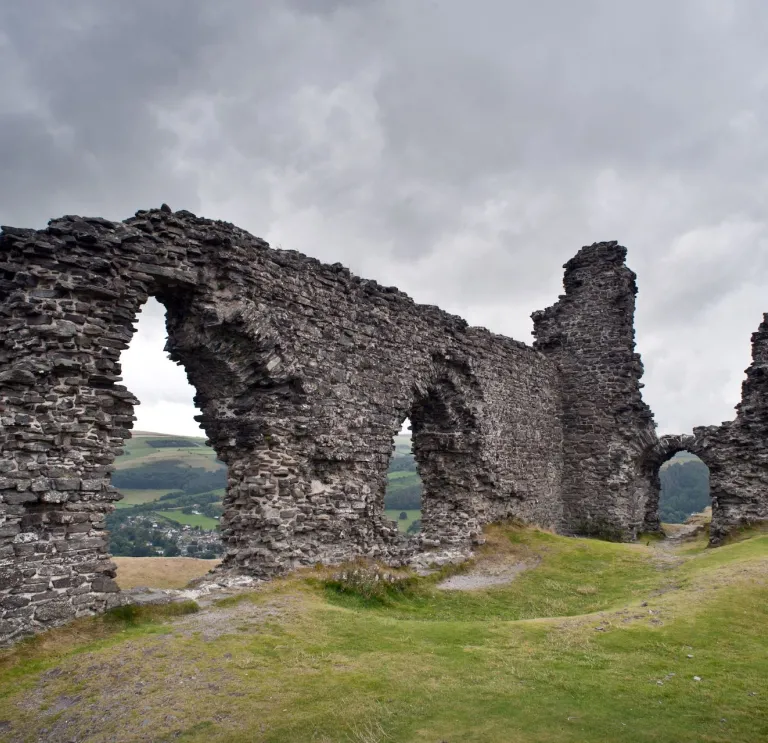
Built in the 1260s by a local Welsh ruler, Prince Gruffudd ap Madoc, to guard the strategic route through the Dee Valley, Castell Dinas Brân appears as an impressive landmark throughout this route. Although little remains of this once great castle, it is well worth the steep climb for the spectacular views over Llangollen and the surrounding countryside below.


Eglwyseg Escarpment
You can lengthen your walk to take in the impressive limestone Eglwyseg Escarpment, visible as a white scar on the landscape for much of the route. It was formed some 350 million years ago in a warm, shallow tropical sea teeming with life, which you can now see as fossils. The screes have accumulated since the end of the last Ice Age, some 11,000 years ago, as millions of angular pieces of rock have been dislodged by frost.


Offa’s Dyke
If you want to lengthen your walk, you can join the Offa's Dyke Path National Trail. Offa's Dyke was built by the King of Mercia between 757 and 796 AD to form the boundary between England and Wales. It runs 182 miles from Prestatyn in the north to Sedbury, near Chepstow in the south.
There are many places along Offa's Dyke Path which are classed as strenuous walks.
Be safe!
- Please take care, remember to wear appropriate clothing and footwear, and follow the Countryside Code.
- Adventure Smart UK has plenty of advice on how to ‘make a good day better’, and we recommend you read it before planning your walking adventures.


